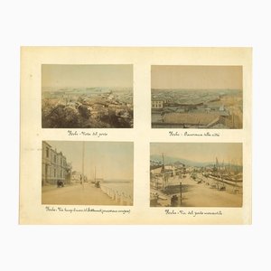
Braun G., Hogenberg F., ''Orleans, Bourges'', from the collection ''Civitates Orbis Terrarum'', Cologne, T. Graminaeus, 1572-1617. Image Dim: cm 37 x 46.5 Dim: cm 40.5 x 53.5. Interesting B/W Aquatint showing an Antique View of Orléans and Bourges, on the shore of the rivers: Loire and Auron. Well visible, the Holy Cross Cathedral, destroyed during the wars of religion in 1568 and subsequently rebuilt by Henry IV in 1600. Very Good conditions, with some light stains on margins. The “Civitates Orbis Terrarum” (Atlas of Cities of the World) was the second oldest printed atlas in the history of world cartography and the first atlas totally dedicated to topographical views. The first volume of this collection was published at Cologne in 1572; the others following in 1575, 1581, 1588 and 1598. The sixth and final volume appeared in 1617, just before the extensive devastation wreaked by the Thirty Years’War. “The most original and magnificent of all city-atlases, which drew on the work of accomplished topographical artists; and…reproduced it in pictorial compositions of great charm and individuality”. R.A.Skelton This artwork is shipped from Italy. Under existing legislation, any artwork in Italy created over 70 years ago by an artist who has died requires a licence for export regardless of the work’s market price. The shipping may require additional handling days to require the licence according to the final destination of the artwork.
Braun G., Hogenberg F., ''Orleans, Bourges'', dalla collezione ''Civitates Orbis Terrarum'', Colonia, T. Graminaeus, 1572-1617. Dimensioni immagine: cm 37 x 46,5 Dimensioni: cm 40,5 x 53,5. Interessante acquatinta in bianco e nero raffigurante una veduta antica di Orléans e Bourges, sulle rive dei fiumi: Loira e Auron. Ben visibile la Cattedrale di Santa Croce, distrutta durante le guerre di religione nel 1568 e successivamente ricostruita da Enrico IV nel 1600. Condizioni molto buone, con alcune leggere macchie sui margini. Il "Civitates Orbis Terrarum" (Atlante delle città del mondo) è stato il secondo più antico atlante stampato nella storia della cartografia mondiale e il primo atlante totalmente dedicato alle vedute topografiche. Il primo volume di questa raccolta fu pubblicato a Colonia nel 1572; gli altri seguirono nel 1575, 1581, 1588 e 1598. Il sesto e ultimo volume apparve nel 1617, poco prima dell'ampia devastazione causata dalla Guerra dei Trent'anni. "Il più originale e magnifico di tutti gli atlanti cittadini, che si avvaleva del lavoro di abili artisti topografici e... lo riproduceva in composizioni pittoriche di grande fascino e individualità". R.A.Skelton Questa opera d'arte viene spedita dall'Italia. In base alla legislazione vigente, qualsiasi opera d'arte in Italia creata più di 70 anni fa da un artista deceduto richiede una licenza per l'esportazione, indipendentemente dal prezzo di mercato dell'opera. La spedizione può richiedere giorni di gestione aggiuntivi per richiedere la licenza a seconda della destinazione finale dell'opera.


Contattaci
Fai un'offerta
Abbiamo notato che sei nuovo su Pamono!
Accetta i Termini e condizioni e l'Informativa sulla privacy
Contattaci
Fai un'offerta
Ci siamo quasi!
Per seguire la conversazione sulla piattaforma, si prega di completare la registrazione. Per procedere con la tua offerta sulla piattaforma, ti preghiamo di completare la registrazione.Successo
Grazie per la vostra richiesta, qualcuno del nostro team vi contatterà a breve.
Se sei un professionista del design, fai domanda qui per i vantaggi del Programma Commerciale di Pamono